Profile of District Ramban
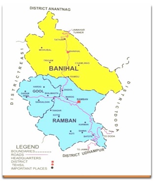
District Ramban is situated on the foot hills of Siwaliks on the banks of river Chenab in Jammu Province. The District is all mountainous and has a tough terrain. River Chenab passes through the lower part of the district in between steep mountain ranges and is a river of high economic importance. Chenab basin is surrounded by high mountains with a number of ridges, valleys , terraces, gullies, springs and streams. The District is also a gate way to the Valley of Kashmir . It came into existence in the year 2007 and earlier it was a part of the undivided Doda District which had a distinction of being the second largest District of the State because of its gigantic size and exceptionally unique and most difficult Himalayan hilly terrains. The District is mostly rural and only 4% population resides in towns (Ramban, Batote & Banihal). The total geographical area of the district is 1329 Km2. It comprises of eleven blocks covering 129 Panchayats and 132 villages. The climate ranges from intermediate in low altitude areas to temprate in high altitude hilly areas. Agriculture is the main source of livelihood in the District likewise in the rest of the state. Horticulture has also assumed importance and makes a handsome contribution towards farmers income. Livestock rearing is an important occupation of the village folks in general and migratory population in particular. Crops are grown from an elevation of 723 meters (Ramban) to 2590 meters (Mahu) above MSL. The Indus river system has carved out a number of valleys in which Agriculture is practiced. The wide range of altitude and topography provides an agro-climatic diversity that enables round the year production of some of the crops such as peas, potato and vegetables. Most of cultivated area is covered under double cropping (Maize- Fodder, Maize -Wheat, Paddy- Fodder/ Oilseeds etc) and cropping intensity is >150%.
Location :
Ramban is located at 33º 14' N latitude and 75º 17 ' E longitude . Ramban town which is the District Headquarter is located at an altitude of about 723 meters on the bank of river Chenab and the peak height in the District is 3280 meters. The average elevation of the District is about 1176 meters. The boundary line of the District extends from Patnitop in its South, Assar on its East, Gool on its West and Banihal in the North.The District is separated from Kashmir valley by the Peer Panjal range of mountains .
District Statistics at a Glance:
Climate:
There are two meteorological observatories at Banihal and Batote at elevations of approximately 1630 and 1585 metres respectively in the district. The climate of the district varies according to its altitude. The meteorological parameters recorded at these observatories may be taken to describe the climate for this district. The district has an intermediate to temperate, extreme type of climate while it is hot and dry in summer and cold and humid in winter. Nights are generally cool being in the foothills of the Himalayas. Winter starts from the middle of November when both day and night temperatures fall rapidly till early February. The temperatures start to rise from March to July and remain steady till September. The period of mid-March to June is of summer season and is followed by southwest monsoon season till September. October to mid-November is of post monsoon season.
Rainfall:
Records of rainfall in the district are available for two rain gauge stations viz. Batote, Ramban and Banihal for a period ranging from 12 to 40 years. The details of rainfall at these stations and for the district as a whole are given in Tables 1 and 2. The average annual rainfall in the district is 1330.7 mm. The annual rainfall in the district varies over a large range. The rainfall in southwest monsoon season (June to September) is about 30% of annual normal rainfall, while pre-monsoon months (March to May) contribute 31% of the annual rainfall. March is the month with the highest rainfall with an average of 211.7 mm. The winter months (December to February) contribute about 33% of the annual rainfall. In the period 1951 to 2000, the highest annual rainfall of 155% of the normal was recorded in year 1990, while the lowest was 30% of the normal recorded in 1952. During this period, there were nine years in which the rainfall was less than 80% of the normal. Such a low rainfall occurred in two consecutive years twice and in three consecutive years once. It is seen from Table 2 that annual rainfall was between 1001 mm and 1600 mm in 19 years out of 35 for which whole year data is available. In high mountains, significant amount of precipitation is received in the form of snow. Snowfall mainly occurred in the winter months; November to March. About 80% of snowfall occurred in the months of December to February. On an average there are 68 rainy days (i.e. days with rainfall of 2.5 mm or more) in a year in the district. This number varies from 47 at Ramban to 84 at Batote observatory. The heaviest rainfall recorded in 24 hours at any station in the district was 255.4 mm at Batote observatory on 23rd August 1996.
Temperature:
The temperatures are high in low altitude areas like Ramban town located in between steep mountains and Chenab river. Temperature and other meteorological conditions depend on the topography of the place. Winter season is from the middle of November to mid-March. Temperatures begin to decrease from the middle of November till early February. January is the coldest month with mean maximum temperature of about 10°C and mean minimum temperature of about 0.5°C. While in the low altitude area like district headquarters Ramban, both the temperatures are 4°C to 6°C high with reference to observatory stations. In association with cold waves, the minimum temperature may sometimes drop to below —10°C on individual days. The day and night temperatures both begin to rise from March and continue till July and remain more or less equal up to August. The day temperature reaches its highest in June or July, which is the hottest month with mean maximum temperature of about 28.0°C and mean minimum temperature is 17.6°C. While at Ramban mean maximum and minimum temperatures are about 34°C and 22°C respectively. On some days, during the period May to July the maximum temperature reaches 35°C in higher altitudes and about 40°C at low altitude area like Ramban. The temperatures are 5°C-10°C lower at high elevated areas with reference to Banihal/Batote. The period of summer and post monsoon season is pleasant with cool atmosphere. The highest maximum temperature and lowest minimum temperature ever recorded in the district are 36.6°C on 31st May 1988 at Batote observatory and -13.6°C on 12th December 1964 at Banihal observatory respectively.